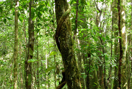
Paluma Wet Tropics Rainforest (©Vilis Nams)
In brilliant morning sunshine, I cycled into Annandale and crossed the pedestrian bridge at Aplin’s Weir to loop back to our home. The parkway lawns and the landscape of savannah woodland surrounding the city already appeared to be yellowing and dry in comparison with the rich lushness of the rain-soaked pastures and forests of the Atherton Tablelands through which we travelled yesterday and on the weekend. The persistent rain that swept over the Tablelands, Misty Mountains, and sugarcane and banana plantations north of Paluma had, however, faded into clear skies and sun before we reached Townsville last evening.
Within Queensland, the wet tropics climatic zone receives 1.2 to over 4 metres of rain annually and stretches for 400 kilometres in a narrow strip 15 to 60 kilometres wide, from just north of Cooktown on Cape York Peninsula to Bambaroo, about 80 kilometres north of Townsville.1 There, the transition to dry tropics occurs. However, the uplands of Paluma Range National Park to the south of Bambaroo, which we have explored three times, also lie within the wet tropics climatic region.1
Half of the 1.8 million hectares of Queensland’s wet tropics is now protected within the Wet Tropics World Heritage Area, and of that, two-thirds is rainforest.1 The rest is open, eucalypt-dominated woodland.1 Much of the rainforest is new-growth forest, since large tracts of the area were heavily logged prior to the Heritage Area designation in 1988.1 In addition to logging, many native wet tropics ecosystems were ravaged or completely destroyed by mining, agriculture, and horticulture after settlement by Europeans.1 The fields of sugarcane and bananas north of Paluma and the verdant dairy farms on the Atherton Tablelands now occupy land that once supported native wet tropics vegetation.
Of great interest to me is the fact that the wet tropics region is one of astonishing biodiversity. However, that tremendous variety of plant and animal species is vulnerable. More than 400 plant species and over 70 animal species inhabiting the wet tropics are classified as rare or threatened.1 These include the bull kauri pines we saw at Lake Barrine, and the tree kangaroos for which the aerial rope ladders across the Palmerston Highway were built. Many species occuring within the wet tropics – even those that occur commonly within that zone – are endemic to that region, that is, they’re found nowhere else in the world. The spotted catbird that yowled from high in a tree in Paluma, as well as the operatic chowchillas that scratched amid the forest litter of the Paluma rainforests, are examples of such endemics.
We’ve hiked through some of the dense, tangled rainforests of Queensland’s wet tropics, but many more sites within that climatic zone are on our travel list – Girringun National Park, Hinchinbrook Island, Kuranda, and especially Daintree National Park north of Cairns. The last is 1200 square kilometres of rainforest2– the largest expanse of wet tropics rainforest in North Queensland and the oldest rainforest in the world.3 Scientists have identified more than 3000 species of plants living within the Daintree, of which 700 are endemic.3 That long-established forest ecosystem is home to two-thirds of Australia’s butterfly and bat species, and almost a third of the country’s species of marsupials, reptiles, and frogs.3 When the temperature in the far north of Queensland drops to bearable hiking conditions, we’re heading there – to the Daintree.
References:
1. The University of Queensland, Centre for the Government of Queensland. Wet Tropics. Accessed 7-May-2010. http://queenslandplaces.com.au/wet-tropics
2. Emma Gregg. The Rough Guide to East Coast Australia. Rough Guides, New York. p. 605; 3. Ibid, p. 606.
