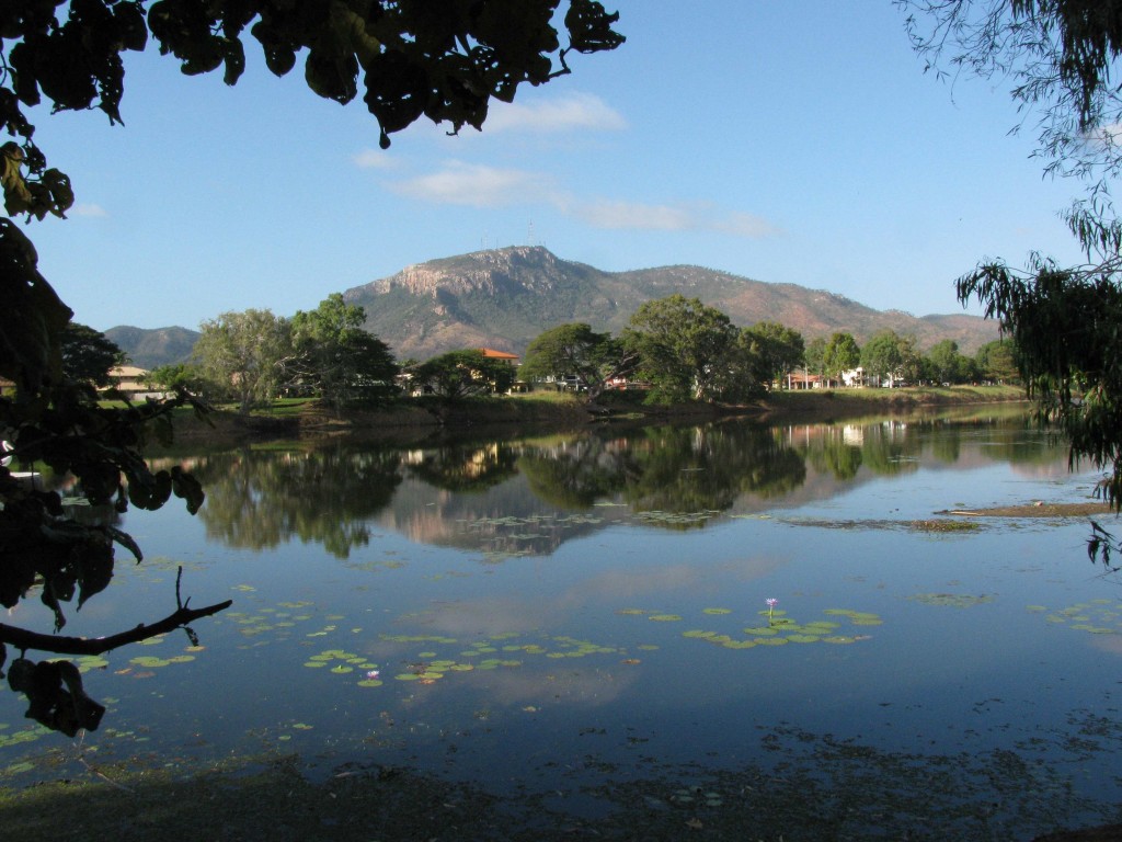
Ross River and Mount Stuart (© Magi Nams)
The Ross River gleamed blue and smooth beneath a clear sky smeared with bits of cloud as I cycled to the Ross River Bush Gardens early this morning, mentally ticking off bird sightings and voices as I rode. The parkway and gardens rewarded me with a richness of species even more satisfying than usual after the paucity of birds I observed on Magnetic Island. At Aplin’s Weir, a white-faced heron preened atop the lone tree protruding from the mass of red boulders downstream from the weir. A little egret and Australian pelican stood motionless atop a cylindrical concrete structure in the river, while an anhinga – all graceful angles – perched within a circular pipe-fitting near the base of the structure. Welcome swallows swooped and banked in pursuit of insects, causing me to once again muse that were I to be offered the opportunity to be a bird, my choice would be one of these agile, long-winged, fork-tailed beauties.
I crept through the Bush Gardens, scanning the shore of the man-made adjacent island, which is now even more accessible because of the growing drought, and walked to an observation deck situated out over the near-shore water. From the deck, I observed Pacific black ducks and a lone magpie goose cruising the river and intermediate egrets hunting in the shallows on the far side of the waterway. Mount Stuart reared up to the south, its pink granite cliffs lit by morning sun, its rough and striking elevation prodding my mind into thinking about Queensland mountains and, more generally, about the topography of all of Australia.
Coastal North Queensland is blessed with ranges of low peaks – Paluma Range, Seaview Range, Gorge Range, Cardwell Range, Walter Hill Range, Lamb Range, and more as you head north from Townsville. Inland from these ranges, the Great Dividing Range of eastern uplands lies within 50 kilometres of the coast at Port Douglas and stretches south to Tasmania. During our road trip to Undara Volcanic National Park three weeks ago, Vilis and I crossed the Great Dividing Range en route to the park. To the west of the Range, flat savannah woodland stretched seemingly endlessly, its low profile occasionally interrupted by old scoria cones and shield volcanoes pimpling the landscape.
For the most part, Australia is not a mountainous country. Its average elevation is less than 300 metres, with only 6% of its landmass rising above 600 metres.1 It is the lowest and flattest of the world’s continents, as well as being the driest (except for Antarctica).2 Satellite images show a vast interior of red, arid land surrounded by fringes of green along the coasts. If you were to travel the entire breadth of this continent from east to west, you would encounter in turn each of four major topographical regions – lowland coastal plains, eastern uplands, central plains, and western plateau.1
The coastal plain of the east, with its sandy, relatively fertile soil (Australia’s soils are ancient, weathered, and impoverished in comparison with North American soils6), supports regions of intensive agriculture and the country’s largest cities – Brisbane, Sydney, Melbourne. The eastern uplands or Great Dividing Range rise 300 to more than 2100 metres in elevation and separate the coastal plain from the central plains in the middle of the country.1 High enough to form a barrier to weather systems moving in from the ocean, the uplands, in addition to dividing the rivers of Queensland, New South Wales, and Victoria into east-flowing and west-flowing drainages, play a prominent role in causing the generally high rainfall experienced on the coastal plain and the aridity of the interior central plain.3 Mount Kosciusko in the Snowy Mountains of New South Wales is the highest peak of the Great Dividing Range, at 2228 metres, and the highest elevation on the Australian mainland.4 The highest elevation in all of Australian territory is Mawson’s Peak, the summit of Big Ben, an active volcano on Heard Island near Antarctica.4
Australia’s central plain contains vast salt pans and deserts (notably the Simpson Desert with its red sand dunes 20 metres high5), as well as the continent’s lowest elevation at Lake Eyre in northern South Australia, which is 15 metres below sea level.1 Westward beyond the central plain, the western plateau accounts for most of the western half of Australia and includes both ‘bigger plains’ (sand ridges interspersed with rocky wastes) and the country’s largest deserts1 – the Gibson Desert, Great Sandy Desert, and Great Victoria Desert.
A glance at a map of Australia shows only two major coastal indentations – the Gulf of Carpentaria in the north and the Great Australian Bight in the south.1 Offshore in the northeast, the Great Barrier Reef roughly parallels the coast for more than 2000 kilometres.1 The country possesses only one major river system with permanent, year-round flow – the Murray-Darling-Murrumbidgee system in the southeast, and the continent’s largest lakes are land-locked and often dry.1 In summary, this red continent lies like a worn and rumpled shield tossed onto the southern ocean, largely barren and ever scorched by the sun.
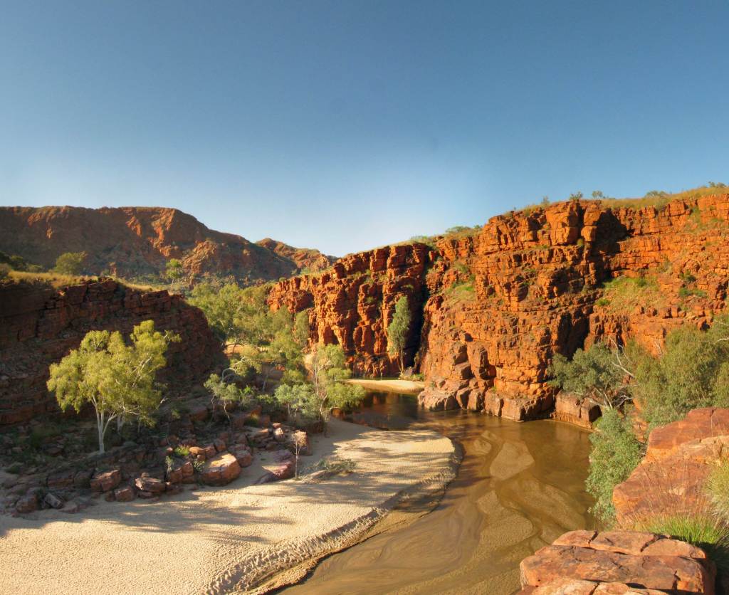
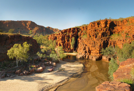
Trephina Gorge in Trephina Gorge National Park, Northern Territory (© Vilis Nams)
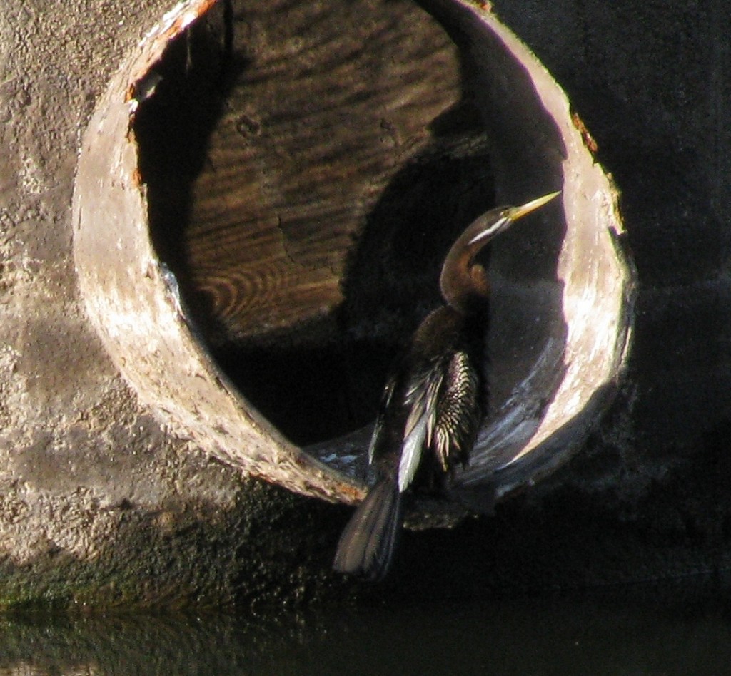
Anhinga at Aplin’s Weir (© Magi Nams)
Today’s birds: sulphur-crested cockatoos, house sparrows, white-gaped honeyeaters, peaceful doves, rainbow lorikeets, magpie-larks, laughing kookaburra, figbirds, yellow-throated miners, great bowerbirds, masked lapwings, Australian magpies, rock doves, blue-faced honeyeaters, brown honeyeaters, mynas, rainbow bee-eaters, welcome swallows, anhinga, white-bellied cuckoo-shrike, white-faced heron, Australian pelican, little egret, intermediate egrets, Pacific black ducks, comb-crested jacana, spangled drongos, white-throated honeyeaters, whistling kite, yellow honeyeaters, leaden flycatcher (f), Australian white ibises, magpie goose, galahs, bush stone-curlews.
References:
1. Encyclopedia of the Nations. Asia and Oceania, Australia – Topography. © 2010 Advameg Inc. Accessed 09-Aug-2010. http://www.nationsencyclopedia.com/Asia-and-Oceania/Australia-TOPOGRAPHY.html
2. Australian Government, Geoscience Australia. Geoscience Basics; Fabulous Facts about Australia. Updated 08-Feb-2010. Accessed 10-Aug-2010. http://www.ga.gov.au/education/geoscience-basics/index.jsp
3. Australian Government, Bureau of Meteorology. Climate Education; Climate of New South Wales. © 2010. Accessed 10-Aug-2010. http://www.bom.gov.au/lam/climate/levelthree/ausclim/ausclimnsw.htm
4. Australian Government, Geoscience Australia. Geoscience Basics; Landforms; Highest Mountains. Updated 23-Dec-2009. Accessed 09-Aug-2010. http://www.ga.gov.au/education/geoscience-basics/landforms/highest-mountains.jsp
5. Government of South Australia, Department of Environment and Natural Resources. South Australian National Parks and Reserves; Simpson Desert Conservation Park; Natural Attractions. Updated 30-Jun-2010. Accessed 10-Aug-2010. http://www.environment.sa.gov.au/parks/sanpr/simpsondesertcp/natural.html
6. Australian Government, Australian Natural Resources Atlas. Soils – overview. Updated 15-Jun-2009. Accessed 10-Aug-2010. http://www.anra.gov.au/topics/soils/overview/index.html
