Vilis and I departed Mount Isa in fresh early morning, embarking on our second day of determined driving toward Townsville from Alice Springs and the Red Centre beneath absolutely clear, cloudless sky that arched over the earth like a pale blue bowl. Changing drivers every hour and a half, we retraced our path through the rolling, rocky uplands between Mount Isa and Cloncurry, the leaves of gum trees and shrubs highlighted in brilliant green by the long-angled rays of the low, morning sun. Between Cloncurry and Richmond, dry, grey-tinged rangeland speckled with scattered trees and dry riverbeds stretched for seemingly endless kilometres, appearing more barren and dessicated than the heart of the rain-lush, red desert we had explored earlier in the week. Yet those bleached, barren grasslands of western Queensland lay above the largest source of fresh water on earth3 – the Great Artesian Basin.
The Great Artesian Basin is a vast underground reservoir of fresh water created over millions of years by the processes of rock formation and geological uplifting.1 It underlies almost a quarter of the land area of Australia,2 encompassing much of Queensland west of the Great Dividing Range, the southeast corner of the Northern Territory, and northern sections of South Australia and New South Wales.1,2 Freshwater collects within this reservoir because of alternating layers of two rock types comprising the earth’s crust in this region – impermeable siltstones and mudstones created as a result of the presence of inland seas long in the past, and porous sandstones created as a result of sediments deposited by rivers during periods between the inundations of the sea.2 Central also to the formation of the water reservoir was the geological uplifting of the eastern border of the basin when the Great Dividing Range was formed, and to a lesser extent, the uplifting of the western edge of the basin.1 The uplifting ‘broke’ the rock layers and exposed porous sandstone along the basin’s borders.
Over the millenia, rain falling on the Great Dividing Range (the recharge zone for the reservoir) seeped down through the exposed sandstone to collect within layers of sandstone far underground.1,2 And there it remained, some naturally springing upward under pressure exerted by impermeable rock above and below, through cracks and out of the ground via artesian springs.2 Water released from such pressurized, water-saturated layers of sandstone, which are called aquifers,2 may be incredibly old. For artesian spings in South Australia, in the southwest corner of the Great Artesian Basin, as many as 2,000,000 years may have passed since that water first seeped into exposed sandstone on the western edge of the Great Dividing Range.2
Artesian springs and streams have been the lifelines of Aboriginal peoples for tens of thousands of years.1,2 After European settlement, it was the realization of the existence of the Great Artesian Basin that enabled graziers to sink bores to bring artesian water to the surface, thus allowing the expansion of grazing lands1 into regions that, like the northwest Queensland landscape through which we drove, appear bleached, dry, and barren.

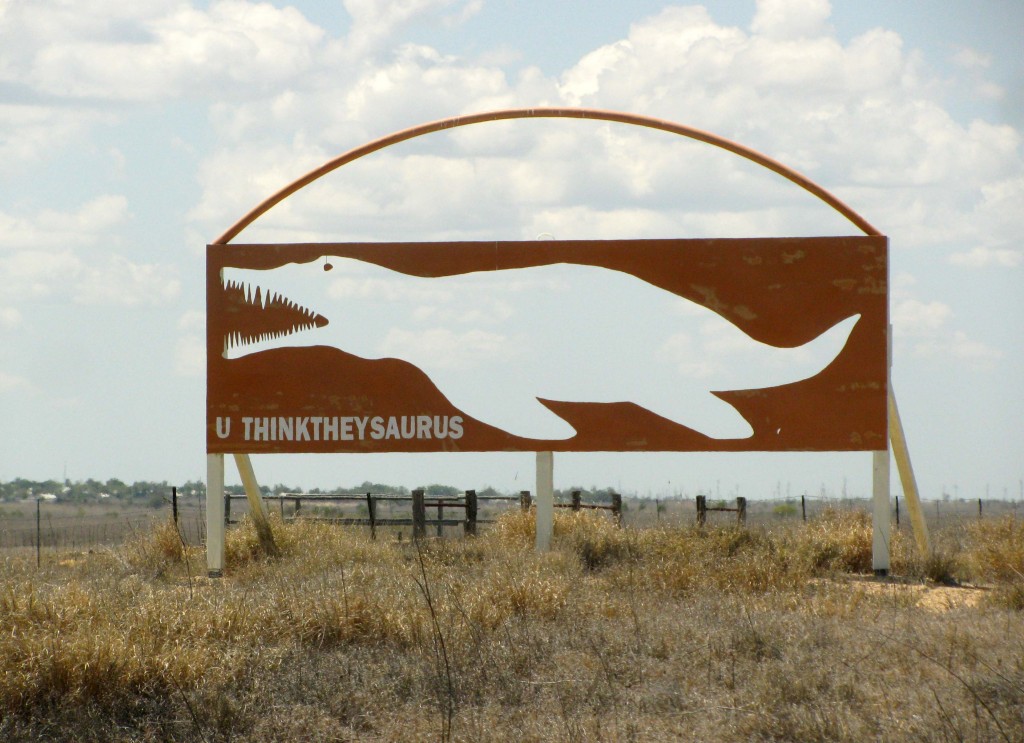
Sign near Richmond, Queensland, above the Great Artesian Basin (© Magi Nams)
Between Julia Creek and Richmond, two emus took long steps through bleached grasses. They were the only emus we observed during our entire, eight-day excursion to and from the Red Centre, which surprised me. Near Richmond, puffy, white cumulus clouds appeared in the brilliantly blue sky, and a U THINKTHEYSAURUS sign was another reminder of the fact that Australia’s east was long ago repeatedly inundated by marine waters in which swam amazing creatures, some becoming fossilized in seabed sediments that eventually hardened and formed the roof of the Great Artesian Basin.4
When we paused for a hasty lunch at a rest stop between Richmond and Hughenden, we noticed that humidity had infiltrated the hot air, and green had infused pasture grasses. Behind us was the dry air of the interior and the vast, bleached grasslands of western Queensland. We’d entered a lusher realm, this one within the sultry reach of the coast.
References:
1.Queensland Government, Natural Resources and Water. The Great Artesian Basin. March 2006. Accessed 6-Oct-2010. http://www.derm.qld.gov.au/factsheets/pdf/water/w68.pdf
2. Great Artesian Basin Coordinating Committee. Water Down Under – the Great Artesian Basin Story (DVD promo). 2008. http://www.gabcc.org.au/public/content/ViewCategory.aspx?id=76
3. Wikipedia. Great Artesian Basin. Updated 30-Sep-2010. Accessed 6-Oct-2010. http://en.wikipedia.org/wiki/Great_Artesian_Basin
4. Malcolm Gordon. Outback Australia: A Guide to the Northern Territory and Kimberley. 2000. Little Hills Press, Seven Hills, New South Wales, p. 75.


